
For those that may not know, the Demilitarized Zone (DMZ) is a 250 km strip of land running across the Korean Peninsula near the 38th parallel. It was established in 1953 during the armistice that halted the Korean War to serve as a buffer zone between North and South Korea. It's approximately 4 km wide, with the Military Demarcation Line (MDL) running down the middle, and it is heavily militarized on both sides.
Some call it the "scariest place on Earth"...so, of course, I had to go see it.
My morning started out early and serene, with a quick stop to take a photo of this unique sculpture and the rising sun reflected in a nearby building.

Then I boarded a bus at the USO for the day-long tour. We headed northwest of Seoul towards Panmunjeom, or the Joint Security Area (JSA). We were briefed at Camp Bonifas on the history of the area and the rules we had to follow, and we were asked if we planned to defect to the north that day. Nope.

Picture taking was restricted before we were at the actual area where the DML runs through the conference buildings. Then we were allowed to take as many as we wanted of the northern view.

If you look closely, you can see a cement dividing line running between the two blue UN buildings, with gravel on the South Korean side.

You can also see one solitary North Korean soldier standing guard at the top of the steps.

Inside the conference building is a long table with microphones running down the center (marking the DML) and guards watching over things. I was standing in two countries at the same time.


Here, while looking out the window, I was standing in North Korea...


...and then I made it safely back to South Korea. We continued on with our tour, heading to an observatory post overlooking the "Bridge of No Return", which was the site of POW exchanges after the war.

We could also see a bit of North Korea's Kijŏngdong or "Peace Village", with its super tall flag pole (coming in at 160 meters, or 525 feet). It is believed that this is not actually a working village, so it is often referred to as "Propaganda Village". The buildings do not have glass windows (they are painted on). We were told that lights come on at night, but they are brightest at the top and then fade out as you look lower, suggesting that there are no floors inside the apartment buildings.

We could also see the small, white markers along the tree line, which mark the DML throughout the entire DMZ.

We drove up to the bridge to snap a few photos.

I noticed we had an inquisitive creature monitoring our tour. I actually read in a book lately that the DMZ is one of the best wildlife preserves in the world, as no human is able to cross through it (especially if they don't want to stumble upon one of the many land mines scattered throughout).

We drove past the site of the 1976 Axe Murder Incident, which occurred when members of the southern forces attempted to trim a large poplar tree that was blocking their line of site to the bridge. The circle represents the size of the tree. JSF Company Commander Captain Arthur Bonifas was one of the two soldiers killed and the nearby military post is named for him.

Next stop on the tour was Dorasan Station, which is referred to either as the last train stop in South Korea or the first stop of the transcontinental railroad to the north. From the map in the station, one could travel all the way from South Korea to Europe if the line is ever able to operate fully through North Korea.


It's a very nice station, fully equipped with a customs area that has never been used.

One train comes into this station twice a day - the DMZ tour train. For 500 won (roughly 50 cents), we could purchase a "ticket" to go see the platform area and gaze toward the north. This area was guarded by military, as well. Anyone up for a short trip to Pyeongyang?


It was time for our lunch break, so we stopped at the nearby highway transit building's Dora Restaurant and had a tasty cafeteria meal of bulgogi and various side dishes.


This was right next to the gate leading to North Korea for workers at the joint Kaesong Industrial Park.

We headed to the Dora Observatory for another view of North Korea. As you can see from the sign on the building, there are many places that say things about ending the separation and reunifying the north and south.

It was a pretty hazy day, so the view was not too good, but the thing of note this day was the scorched earth nearby (and scent of burnt wood in the air). A wild fire had broken out earlier in the week in North Korea and entered the DMZ, passing into South Korea and coming up to the observatory. From news reports, it was difficult to fight the fire on either side due to the obvious problems getting to it, and it was finally extinguished using approved helicopters. You can see the blackened areas in this photo.


I found this picture to be an interesting study of Buddha framed in razor wire...

As we traveled to our last stop, I noticed the area all along the DMZ has two things of note - land mine warning signs and farmland.


Our last stop on the tour was the Third Infiltration Tunnel. Even here, in such a serious place, there was a photo op stop and cute mascot.

The tunnel was discovered in 1978 and was considered the most threatening to Seoul, as it's only about 50 km away. It's 1,635 km long and 30,000 soldiers could have moved through it in one hour. The portion on the southern side of the MDL is open for tourists to explore, up to the 1st of three cement barricades that were installed.

Here's a little more info about the tunnel's discovery:

We all donned one of these hard hats:

...and then we started the walk down into the tunnel.

No picture taking was allowed in the tunnel (though I did see teachers taking pics of their students as we went back up) and honestly, it was pretty dank and dark to attempt it. I'm average height, so I didn't have too much trouble navigating the low ceilings, but anyone over 5'10'' would probably need to duck and hunch over for most of the way. The walk was peppered with the sound of helmets repeatedly hitting the pipes and rock.
The following pic is of the above ground mock-up of the end of the tunnel. It's pretty close, including the rubber strip mat that lines the entire length.

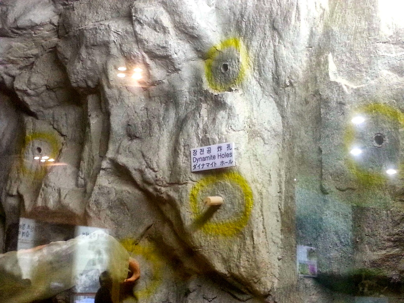
This pic, from the nearby museum, shows how the walls are marked in the tunnel - the yellow paint marks the dynamite holes throughout.
We made it to the end of the tunnel, peered through a small hole to see the next blockade, said "huh, there it is", and turned back the way we came to head back to the surface. I gazed longingly at the nearby rail platform for a direct ride up...but you had to be on the scheduled tour for that one and be wearing blue hardhats. So up I trudged, taking my time on the long, slow incline...everyone was feeling the burn by the time we got to the top. It's definitely not a walk for the faint of heart!
I recovered next to this lovely fountain scuplture:

There were a few minutes to explore the grounds, museum, and hit the gift shop. There's a pretty impressive piece of artwork at the center, signifying the reunification efforts.

Each half of the sphere has one half of Korea on it, making it whole when they are pushed together.

The museum has a full mock up of the JSA from above:

It was a great day and tour. Rob had gone earlier in the year (we decided to go separately, as Michael is too young to go - only kids 10+ in age can go to the JSA). He had described it to me and I wasn't sure I wanted to go, but I'm glad I did. An experience for the memory book!


